Geohazards Monitoring
INSAR IS one of the most effective tools FOR GEOHAZARDS MONITORING AND EARLY WARNINGs
Geohazards are natural phenomena, which are characterised by adverse geological condition, which can be hazardous for people, assets and environment. Geohazards include such phenomena as earthquakes, volcano eruptions, floods, tsunami, landslides, etc.
Geohazards have been one of the largest threats to the human development from the beginning but changing climate patterns, precipitation levels and other anthropogenic factors lead to the growing risks of geohazards lately. Also, growing population and expanding economic activities make the world more vulnerable to their impact.
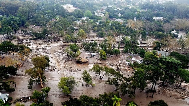
Destructions brought by a landslide in California in 2018
Monitoring Geohazards with InSAR: Protecting Lives and Environment
Geohazards are caused by natural geological processes mostly but can also result from human activities, such as mining, construction, groundwater extraction etc.
Geohazards claim thousands of lives each year. In the USA along 25-50 people are killed each year on average by landslides, not to mention the material damage. Thus, 23 people were killed, at least 167 injured, and more than 400 homes were damaged by a series of debris flows that impacted the California community of Montecito in Santa Barbara County on January 9, 2018. The events were triggered by heavy rain that fell on steep hillsides that had been burned by the Thomas Wildfire some time earlier.
InSAR is one of the most effective tools to monitor for the geohazards such as
- Landslides (Learn more about landslides)
- Subsidence (Learn more about subsidence)
- Sinkholes (Learn more about sinkholes)
- Deformations caused by melting permafrost (Learn more about melting permafrost)
glaciers and other phenomena. It is also very instrumental for analysing the aftermath and response planning for floods, earthquakes and volcano eruptions.
InSAR also offers unique capabilities, which allow to develop effective predictive tools and set up an early warnings systems. These capabilities include high sensitivity to change, i.e. mm precision, which allows to detect very early land movements and track their spatial and temporal evolution, as well as the ability to cover very large areas, which would not be possible to do using conventional tools, such as land surveying, or sensors.
InSAR has already been successfully used by many countries and their Civil protection agencies for the landslide risks monitoring as well as for other risks management. One of the good examples, can be Italy, where the method has been implemented to monitoring for land stability for Valle d’Aosta – a large, mountainous area.
A big step in this direction is also the creation of EGMS – European Ground Motion Service , the first service in the world, which provides free of charge baseline deformation information on the continental (Western Europe) scale.
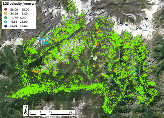
Valle d’Aosta InSAR based stability monitoring
GeoKinesia possesses strong experience in providing land deformations monitoring service to the private and public customers in Europe and across the world and has developed a unique early warning tool, which allows generating in automatic manner early warning signals and track land deformation risks and their development.
GeoKinesia has also developed the 1st EGMS based value-added product Active Deformation Area map of Europe, which allows a user to quickly obtain information on whether the area of his responsibility is affected by a deformation. The service is provided free of charge to all registered users.