EGMS – European Ground Motion Service
The 1st continent scale land motion service, a part of the Copernicus Land Motion service
The European Ground Motion Service (EGMS) is the first ground motion of the continental scale providing information on natural and anthropogenic ground motion over the Copernicus Participating States.
Copernicus ( https://www.copernicus.eu/en ) – is a European Space Agency’s Earth observation program. EGMS has been developed within the frame of this program.
EGMS provides the base line information on the deformations in a convenient visualization tool ( https://egms.land.copernicus.eu/ ) , it also offers some statistical and analytical tools.
The information is updated on the annual basis only, for more frequent updates and ongoing land motion monitoring, specialized service providers, such as GeoKinesia, can be contacted.
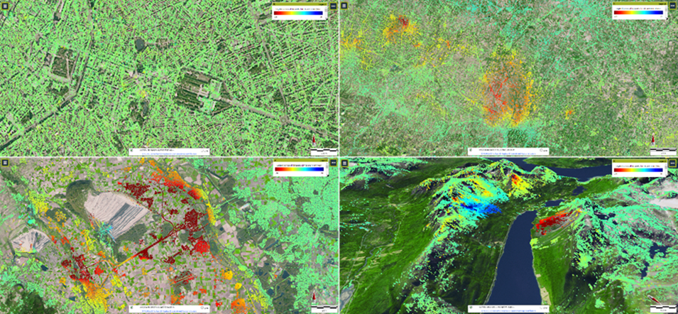
The picture shows four ground motion examples from EGMS (Basic product). Upper left, the urban area of Brussels (Belgium) and the European Parliament; upper right, the Firenze-Prato-Pistoia basin in Italy affected by subsidence due to water exploitation; lower left, ground motion in the surroundings of the Hambach surface mine in Germany; lower right, landslides in the slopes of a fjord near Tromsø (Norway).
EGMS is the first service of this scale and it provides a unique opportunity to study geohazards and human-induced deformation such as landslides, subsidence, volcanic unrerests, melting permafrost, glacier movements, shore erosion and many others. The EGMS also serves as a starting point for investigation of ground motion affecting buildings and linear infrastructures. This is an effective risk monitoring tool.
The EGMS is based on the multi-temporal interferometric analysis of Sentinel-1 radar images at full resolution. This technique allows identifying reliable measurement points for which ground motion velocity values and time series of deformation are extracted. Global navigation satellite systems data are used as calibration of the interferometric measurements.
The EGMS distributes three levels of products:
- Basic: Line of sight velocity maps in ascending and descending orbits with annotated geolocation and quality measures per measurement point. Basic products are referred to a local reference point;
- Calibrated: Line of sight velocity maps in ascending and descending orbits referenced to a model derived from global navigation satellite systems time-series data. Calibrated products are absolute, being no longer relative to a local reference point;
- Ortho: Components of motion (horizontal and vertical) anchored to the reference geodetic model. Ortho products are resampled to a 100 m grid.
In addition, EGMS delivers to users the 50 by 50 km gridded velocity model ( data and report ) used to calibrate the Basic product.
EGMS also serves as the basis for the development of downstream value-added services, using EGMS database.
ADA is a highly convenient tool and a starting point for a risk analysis for a person responsible in charge of an object stability and safety monitoring. It is highly useful for practitioners who are involved in monitoring and maintenance of the buildings and infrastructures such as roads, bridges, pipelines, railways, dams etc. as well as habitational areas.
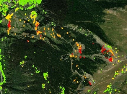
Active Deformation Area map example
GeoKinesia has developed the 1st value added service using EGMS data base – Active Deformation Areas Webmap (ADA). The product provides a user with the access to a convenient visual interface and a simplified database, which shows only active deformation areas and allows seeing if an area of his/her interest might be affected. The tool also allows analyzing the deformation temporal and spatial evolution and obtain time series graphs on its magnitude and velocity. More detailed geotechnical analysis and ongoing monitoring can be ordered from GeoKinesia.
Copyright: Copernicus program, GeoKinesia