Subsidence Monitoring
Understanding and Addressing Subsidence Issues
Subsidence is a gradual settling or sudden sinking of the Earth’s surface owing to subsurface movement of earth materials. The principal causes of land subsidence are aquifer-system compaction, drainage of organic soils, underground mining, hydrocompaction, natural compaction, sinkholes, and thawing permafrost.
Today the biggest problem causing large-scale subsidence in the urban areas is underground water overexploitation. Many megapolises such as Beijing, Mexico-city or Jakarta suffer from large scale subsidence provoked by underground water pumping or other reasons. The problem is expected to aggravate in the future.
Large-scale subsidence can pose risks to the structural integrity of the buildings and infrastructures in the area, causing deformations and, worst case, collapse. The problem is complicated by the fact that the process is gradual and is very difficult to detect, especially at an early stage. The conventional tools such as land surveying or sensors are not suitable for large areas and multiple objects especially in the urban environment. Also, when the initial sings are detected, it is not always easy to attribute them to an area subsidence or other reasons.
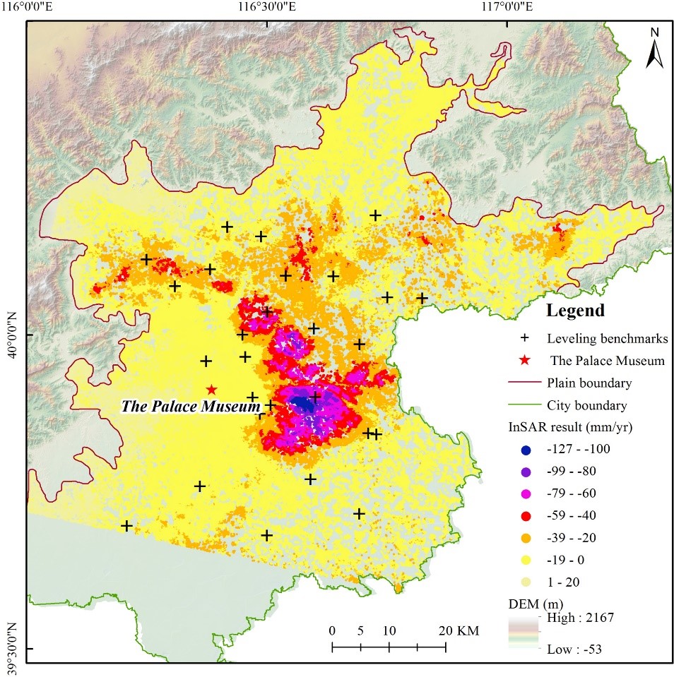
InSAR analysis of the subsidence in Beijing, China. Source: Spatiotemporal heterogeneity of land subsidence in Beijing, G. Duan et al.
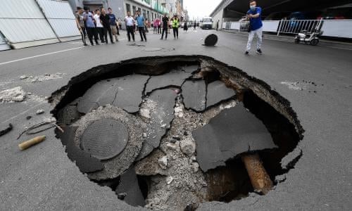
Subsidence induced pothole on a city street, China
Underground water pumping is not the only cause of subsidence. Different types of soft soils, e.g. river delta sediments, naturally compress under their own weight over time, but regular river floods would normally compensate for this by delivering fresh sediments. Cities often confine their rivers to avoid flooding, which stops new sediments from reaching the delta. Damming upstream rivers can also halt sediment delivery, leading to subsidence—and floods.
Land subsidence also further adds to the growing risk of coastal flooding, and oftentimes, the net rate of subsidence exceeds that of sea level rise. In Bangkok, the Gulf of Thailand is rising 0.25 cm per year, but the city is sinking at a far faster rate, up to 4 cm per year. This downward settlement significantly increases flood vulnerability which can ultimately lead to major economic damages and loss of lives.
Draining wetlands is another example of the human activity, which causes subsidence. When wetlands dry, oxygen from the air creeps into the soil and oxygen-breathing microbes start to munch up peat and convert it to carbon dioxide for energy. This shrinks and weakens the soil, leading to subsidence. Although this kind of process affect mostly rural areas some cities, for example, in the Netherlands, are built on the peat soils.
In general, the average subsidence rates vary from 100 mm/year for Jakarta to 80 mm/year for Ho Chi Minh city and to 26 mm/year for New Orleans. Some parts of Mexico City sink at the rate of 50-60 mm/year every year. At the same time, maximum subsidence rates can reach much higher values leading to individual accidents with catastrophic consequences.
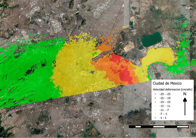
GeoKinesia’s InSAR analysis of the subsidence over some parts of the Mexico-city
InSAR is a highly effective tool for subsidence detection and monitoring. It is probably the only tool, which allows monitoring the urban areas stability and multiple objects in the urban areas environment. It is also highly practical for rural areas. In Europe, EGMS is the first service of the kind, which provides the base line information allowing to analyse subsidence on the European continent.
GeoKinesia possesses strong experience in providing subsidence monitoring in many areas around Spain, Mexico, and more generally Europe, Latin America, Africa and other regions.