Infrastructure Monitoring
InSAR for infrastructure stability monitoring and alert systems
Societal sustainable development relies heavily on the built environment. Infrastructure types within the built environment are considered geo-structures, like earth dams and road and railway embankments. The built environment is vulnerable to sudden effects of natural disasters (earthquakes, floods, etc.) and slow-moving deformations (landslides, subsidence, sinkholes, etc.)
A broad range of monitoring techniques are available to provide real-time and precise information on the stability conditions of infrastructure. These techniques range from traditional land surveying and sensors (GPS, inclinometers, and piezometers) to newer technologies like acoustic sensors, fibre optics, drone-based photogrammetry, etc.
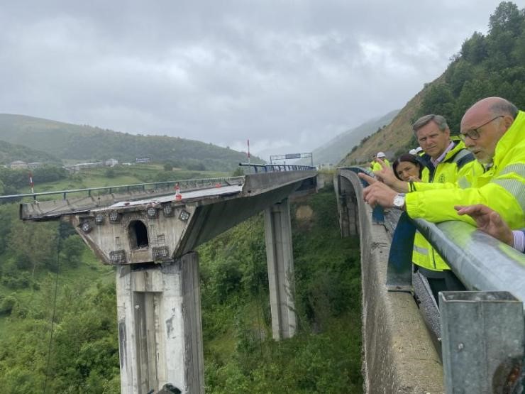
A viaduct collapse in Spain in June, 2022
Enhancing infrastructure safety: InSAR for bridge, dam, and tailings stability monitoring
While the abovementioned techniques are well suited to monitoring large and modern infrastructure (bridges, dams, buildings, or wind turbines), they are often not technically or economically viable for monitoring older and smaller infrastructure. While the data these techniques provide is highly precise and continuous, it remains localised and doesn’t allow monitoring of large or remote areas. Despite all the existing technology, the vast majority of the built environment is only monitored by simple visual observations, if at all.
There is a dire need to reliably and economically sustainably monitor infrastructure and the vast surrounding areas in the developed and developing worlds where infrastructure is ageing and maintenance budgets are insufficient.
Lack of monitoring and maintenance leads to catastrophic events that claim dozens and hundreds of lives, such as the 2018 Ponte Morandi collapse in Italy, the 2022 viaduct bridge collapse in Spain, the 2024 Old Kijabe Dam collapse in Kenya, and the 2019 Brumadinho iron-ore tailings dam collapse in Brazil.
Prevention is better than cure, or at least preparedness is. A great solution to begin any asset or object monitoring strategy is to use remote sensing, especially InSAR, to provide reliable and economically sustainable data on object stability and surroundings. Using InSAR first will enable decision-makers to identify and triage risk areas that require localised monitoring.
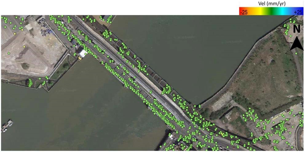
InSAR monitoring of object stability effectively detects early stages of deformation events. It is highly effective in monitoring the stability and surrounding land movements of bridges, dams, buildings, highways and roads, railways, reservoirs, powerlines, dump sites, and remote critical objects and assets. InSAR is irreplaceable for monitoring the stability of large urban areas during underground works or if they are prone to subsidence due to underground water overexploitation or sinkhole formation.
InSAR analysis provides critical insight for the pre-design phase development and a site suitability analysis, as this is the only method that allows analysis based on archived data, historical evolution, and stability of an area.
With our proprietary processing chain we obtain high point density, which allows us to monitor “thin” or small infrastructures more precisely.We detect and assess deformation-related risks early using continuous intelligent monitoring of infrastructures and nearby areas integrated with dynamic numerical modelling.