LAND AND STRUCTURE DEFORMATION
Detection. Monitoring. Prediction
What is InSAR
Microwaves are emitted and their reflections from the surface and the objects on the surface are recorded by the sensors installed on the low orbit satellites, the data are processed by a complex software tools, results are presented as reports or in different GIS.
Unique features
![icon 1 icon 1](https://geokinesia.com/wp-content/uploads/elementor/thumbs/icon-1-q13l6m547f281bp9ubr2s64b9ek03rx7ybxho5uneq.webp)
global reach, independent of sunlight and weather
![icon 2 icon 2](https://geokinesia.com/wp-content/uploads/elementor/thumbs/icon-2-q13lfkjrblbknkoyjp441erf0kewfyh5inp1a2km4i.jpg)
deformations and velocities measured with mm precision
![icon 3 icon 3](https://geokinesia.com/wp-content/uploads/elementor/thumbs/icon-3-1-q13m7fhjvtgiri84v8n1fvo8up3jl02r0js4cb9jpe.jpg)
thousands of measurements over a selected area of interest
![icon 4 icon 4](https://geokinesia.com/wp-content/uploads/elementor/thumbs/icon-4-q13mquth8xxftj39fx5cbvi0vpxdeebi0j23t0uv7m.jpg)
over 20 years of data
![icon 5 icon 5](https://geokinesia.com/wp-content/uploads/elementor/thumbs/icon-5-q13mwmjt2xy7z7mkqmq0s0s23iwqwx3q59bogbwmwy.jpg)
from thousands of sq km to individual objects
![icon 6 icon 6](https://geokinesia.com/wp-content/uploads/elementor/thumbs/icon-6-q13mxwlwkeingbe3a3yjpjlwaxguhyv95c5kl5lole.jpg)
compared with traditional topography or sensors
Complimentary to other sensors
1. GeoKinesia InSAR proprietary processing chain
2. Convenient web-based user interface
2. Predictivity
3. ACR
Where InSAR is used
![1 1](https://geokinesia.com/wp-content/uploads/elementor/thumbs/1-q1a44ft0l0giy34wqm58wije4ljm8wtqzqzs37mziy.jpg)
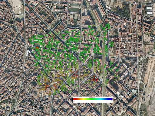
Bridges, dams, roads, tunnels, railways, pipelines, tall buildings, historical and cultural objects. Historical analysis, monitoring, large areas monitoring during underground works. Individual objects monitoring, risk prediction.
![civil civil](https://geokinesia.com/wp-content/uploads/elementor/thumbs/civil-q1a46x3om9url1j796qsze06k7bhk5o900ywohyl3u.jpg)
Pre and post construction monitoring. Historical analysis, monitoring. Risk detection and prediction solution.
![construccion 1 construccion 1](https://geokinesia.com/wp-content/uploads/elementor/thumbs/construccion-1-q1a49shxi1sb25d0hffrlnwvwl5v2v2q28qbgxpa3e.jpg)
Construction and surrounding areas monitoring. Historical analysis, monitoring. Risk prediction.
![natural natural](https://geokinesia.com/wp-content/uploads/elementor/thumbs/natural-q1a4bwmuvmoj6kaf4ucjpmp80sqlecgzcpknccke3e.jpg)
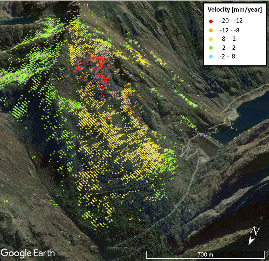
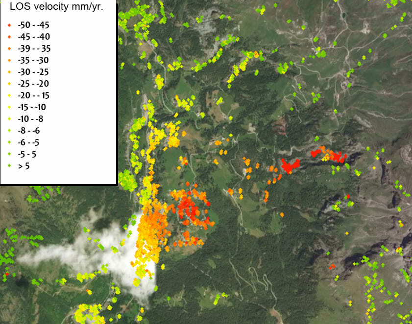
Slopes stability, landslides, sinkholes, erosion, coastal areas, permafrost. Large areas monitoring, early warnings, automatic risks detection and prediction.
![financial financial](https://geokinesia.com/wp-content/uploads/elementor/thumbs/financial-q1a4ffj2i9i8px63jv76k8og7td59hgqu5n74pc8re.jpg)
Real estate and development, infrastructures, civil engineering. Project risks analysis, monitoring, disputes resolution.
We are open to partnerships!
Geotechnical companies
Earth observations companies
Asset monitoring companies
Our Experience
![Gold Mine](https://geokinesia.com/wp-content/uploads/2023/01/experience-1.jpg)
![New underground line construction](https://geokinesia.com/wp-content/uploads/2023/01/experience-2.png)
![Landslide monitoring in Spain](https://geokinesia.com/wp-content/uploads/2023/01/experience-3.jpg)
![Landslide Monitoring in Italy](https://geokinesia.com/wp-content/uploads/2023/01/experience-4.jpg)