
9 MAY, 2025
Newsletter
L-BAND AND THE NEXT FRONTIER IN DEFORMATIONS MONITORING
The stability of the Earth’s surface is a global concern. Climate change, increasing natural resources exploitation and growing urbanisation lead to increased risks of ground deformations, many of which are of a new form and nature, as we have shown in our previous Newsletters.
InSAR—Interferometric Synthetic Aperture Radar – has emerged over the last two decades as a go-to solution for ground movement monitoring. InSAR offers a range of unique advantages: high sensitivity and millimetre precision, ubiquity, archive data for historical monitoring and low costs.
InSAR has proven to be highly valuable in identifying early signs of landslides, monitoring the slow failure of infrastructures or deformations in the surrounding areas. It is irreplaceable during the mining or tunnelling operations as well as for large scale subsidence monitoring.
Yet, despite its clear advantages, InSAR remains underutilized in certain areas and one of the key problems is its sensitivity to surface conditions – snow and vegetation. Traditional InSAR systems, operating in C-band (used by Sentinel- 1) or X-band (like TerraSAR-X), struggle in regions covered by dense forest, bushes, or jungles. The wavelengths cannot penetrate vegetative canopies effectively, resulting in poor signal coherence and, therefore, no usable measurements.
The key to overcoming the barrier is L-band – a radar wavelength roughly 23.5 cm long, which enables it to penetrate forest canopies and return coherent signals, even in densely vegetated environments. L-band is not a new discovery; the early missions such as Japan’s ALOS- 1 and – 2 have provided valuable L-band datasets to researchers. However, the availability of L-band data has so far been limited in resolution, temporal frequency, and commercial readiness.
That is about to change.
Two upcoming missions are poised to revolutionize the availability of L-band InSAR data. The first is NISAR, a collaborative mission of NASA and ISRO (India’s Space Research Organisation), scheduled to launch in 2025. NISAR will be the first radar mission to operate in dual L- and S-bands, with an open-access data policy and a strong focus on Earth science, disaster response, agriculture, and infrastructure. It promises systematic global coverage with frequent revisits, making it a foundational dataset for researchers and practitioners alike.
The second milestone is the ESA’s L-ROSE mission, expected to launch in 2027 , which will be the first fully commercial L-band radar constellation designed specifically for deformation monitoring and also tailored to the needs of civil infrastructure, urban development, and climate resilience. It is expected to deliver high-resolution, high-frequency data optimized for operational use cases.
Together, these missions represent a paradigm shift in InSAR capabilities. For the first time, high- quality deformation data will be available across regions previously considered “difficult”. Applications in landslide early warning, transport infrastructure safety, dams monitoring, and disaster resilience will all become viable and scalable.
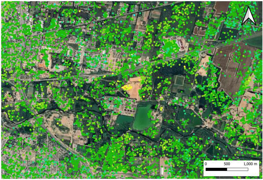
GeoKinesia in partnership with CTTC are well prepared for new data arrival. Over the past year, our team has been working with historical L-band datasets, developing custom processing chains and adapting our deformation analytics to handle the characteristics of L-band signal. The results have been remarkably promising: areas where C-band failed now return coherent and quality signal. Forested valleys, prairies and tropical areas are becoming all “analysable”.
We believe that 2025 – 2027 will mark a turning point in the way the world approaches surface monitoring. L-band will unlock new markets and regions and become a new standard for applications where vegetation and coherence loss were deal-breakers.
GeoKinesia is fully committed to supporting this transition, offering L-band processing services.