Newsletter
Climate change and new land deformation patterns
A few studies demonstrated that climate change leads to changing weather patterns and the frequency of extreme events, such as extreme temperatures, increased precipitation, draughts, floods and hurricanestropical cyclones, storms, typhoons.
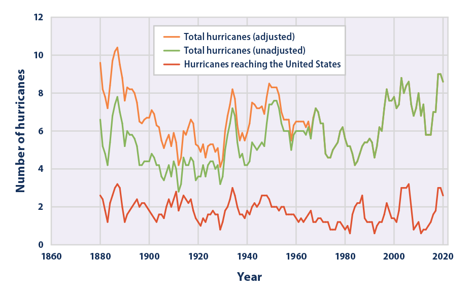
Average number of hurricanes in the US. Adjustment is made for observation methods. Source: NOAA, 2023; Vecchi and Knutson, 2011
While the evidence of temperatures’ rise as well as extreme temperatures increased frequency is conclusive, the frequency of hurricanes’ increase is debated.
Some researchers suggest that hurricanes in the U.S. are now three times more frequent than 100 years ago, and that the proportion of major hurricanes (Category 3 and higher) two times more frequent than 50 years ago.
IPCC (UN’s Intergovernmental Panel on Climate Change) in its “Weather and Climate extreme events in a Changing
Climate” report suggests that there is “high confidence” that humans have contributed to increases in precipitation
associated with tropical cyclones, and “medium confidence” that humans have contributed to the higher probability
of a tropical cyclone being more intense
Changing weather patterns and in particular increased precipitation are well understood but they also cause new types of land deformations or changing land deformations patterns, which are much less studied.
Their emergence, however, pose serious and
unexpected (and not prepared for) threats to
the safety of the societies.
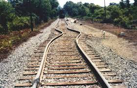
Railways deformation caused by extreme heat in Europe
in 2023
Changing precipitation patterns cause
landslides and mudslides in the areas where
they were not observed before, rising sea
levels result in accelerated shore erosion,
increasing desertification leads to new types of land movements, extreme temperatures cause deformation of rail lines or damage to the autoroutes’ surface. And melting permafrost causes large scale deformations posing a threat to the infrastructures, which were built on the assumption that frozen soils would not move.
Exemplary is the 2020 Norilsk Nickel accident, when melting permafrost led to a deformation of an oil reservoir, which cracked open and produced over 20,000 tons of diesel into the surrounding lakes and rivers and ultimately into the Arctic Ocean. The very modest estimate of the environmental damage is $1,5Bn.
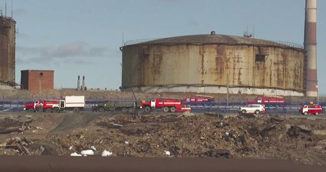
Norilsk Nickel reservoir after the catastrophe
In our last Newsletter we have highlighted the importance of the preparedness for the changing weather patterns and the new types of challenges they bring about, as well as the importance of the preventive monitoring using the latest technologies and in particular remote sensing, which allows early risk identification over vast areas.
Some articles emerged recently, which discuss an interesting phenomenon of so called “underground climate change” or a change in the underground soil temperatures, which lead to displacements of the ground and consequent deformations under the buildings and infrastructures in the urban areas. The phenomenon is new and potentially can be a contributor to the damage in the areas, which already suffer from subsidence or other types of land displacements. We will discuss this new phenomenon in detail in next Newsletters.
#Geohazards #InSAR #SAR #satellite #ESA #Sentinel #ClimateChange #RemoteSensing #Sustainability #GeoKinesia #Geotechnicalmonitoring #Subsidence #Deformations #Displacements #groundmovement